Hold tight - Something is brewing...
Climatological Analysis: The Complete 2025/2026 Townsville Wet Season Review
Author: Chris Nitsopoulos
Posted on: Sunday, May 17th, 2026, 10:21:05 AM

It is May, the dew point has finally dropped, and we can officially classify the 2025/2026 Northern Australian wet season (October 1 – April 30) has concluded.
Moving past general public summaries, the data reveals a highly active, front-loaded wet season driven by deep tropical moisture convergence, historical climate anomalies, and early monsoonal dynamics. For those tracking the meteorology and hydroclimate of the North Queensland coast, here is the statistical and synoptic breakdown of how the last seven months played out across Townsville (Station 032040).
Pre-Conditioning the Atmosphere: The 2025 Build-Up (Oct–Dec)
The official North Australian wet season commences on October 1. While the early months (the "build-up") are typically defined by rising humidity, isolated convection, and high thermal stress, late 2025 deviated significantly from the climatological norm. This quarter was highly anomalous, heavily influenced by converging macro-scale climate drivers that primed the region for severe precipitation.
Macro-Climate Forcing: A Historic IOD and Redeveloping La Niña
The late 2025 period was dominated by a strongly coupled ocean-atmosphere system that supercharged moisture availability over Northern Queensland.
-
Negative Indian Ocean Dipole (IOD): A strong negative phase of the IOD was active through the second half of the year. During the week ending 2 November 2025, the IOD index plummeted to -1.94°C. This was the most severely negative value recorded since the Bureau of Meteorology began its weekly dataset in 2008. This extreme thermal gradient across the Indian Ocean acted as an atmospheric conveyor belt, funneling exceptional volumes of tropical moisture toward the Australian east coast.
-
El Niño-Southern Oscillation (ENSO): Compounding the IOD, oceanic and atmospheric conditions fully coupled by late October to redevelop a weak La Niña, shifting the Walker Circulation and enhancing convective potential over the Coral Sea.
Monthly Synoptic Progression
-
October: The season began with intense solar insolation and a rapid breakdown of the dry season's stabilizing high-pressure ridges. While precipitation was mostly limited to isolated coastal showers early on, the rapidly warming sea surface temperatures drove coastal minimum temperatures well above the long-term average, maximizing the latent heat energy stored in the marine boundary layer. The Coral Sea near Townsville showed rapid warming in this time frame with localised sea temperatures rising in excess of 2 degrees above normal by the end of the month.

-
November:
As the capping inversion weakened, atmospheric instability took over. November was defined by multiple severe thunderstorm outbreaks rather than broad stratiform rain. Driven by the historic negative IOD moisture feed, Townsville recorded frequent, high-intensity convective events late in the month. Notably, a severe thunderstorm complex on 30 November delivered heavy, localized downpours.

-
December:
The transition from isolated convection to macro-scale synoptic rainfall. December 2025 was the catalyst for the flooding that followed. The arrival of Tropical Low 07U, combined with an unusually early onset of the monsoonal trough (officially declared late in the month, but unofficially arrived earlier in North Queensland), delivered sustained, deep-layer moisture. Continuous rainfall drastically suppressed diurnal heating, resulting in anomalously low daily maximum temperatures towards the end of the month while maintaining dangerously high dew points.

This saturated soil profile throughout December completely eliminated catchment buffers, meaning that when the extreme January monsoonal bursts arrived, the landscape was already primed for immediate runoff.
The Deep Wet: Thermodynamic Extremes (Jan–Feb)
The 2025/2026 deep wet season was characterized by a slightly early Northern Australian monsoon onset, officially recorded at Darwin on 23 December 2025, but unofficially impacting the far north of Queensland ahead of its official onset. Anomalously high sea surface temperatures (SSTs) across the Coral Sea provided the necessary sensible and latent heat fluxes to destabilize the troposphere.
From a thermodynamic perspective, the atmosphere's moisture-holding capacity is governed by the Clausius-Clapeyron relation in this relationship, the warmer the boundary layer, the more moisture that the atmosphere can carry. Because saturation vapor pressure scales exponentially with temperature, the elevated marine boundary layer temperatures I mentioned earlier provided a massive reservoir of precipitable water. This deep moisture interacted with a dominant monsoon low and embedded troughs, leading to extreme localised precipitation rates along the coastline especially north of the city.
-
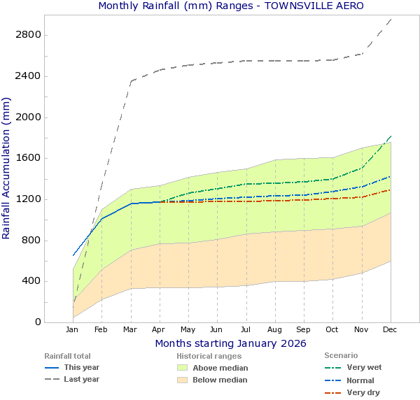
January: The most intense rain event occurred during the initial monsoonal burst. On 1 January 2026, the gauge recorded 223.0 mm, driven by the active monsoon trough and low-pressure convergence.

-
February:
Maintained an exceptionally high rain-day frequency rather than isolated cyclonic extremes. Townsville recorded measurable precipitation on nearly half the days of the month, but with the highest individual rain day producing just 74mm of rain. This constant rainfall caused significant disruption to building projects and pushed year-to-date totals rapidly further above the historical mean.

Late Season Hydrology: The Trough Retreat (Mar–Apr)
Following the massive deluges of January and February, the synoptic forcing shifted, altering the precipitation characteristics over the city.
-
March:
A transition toward sustained, low-intensity precipitation. Townsville recorded 145.0 mm across 19 individual rain days. While we did not see the extreme daily spikes of previous years, the persistence of the rainfall maintained high soil moisture saturation and delayed the drying of local catchments.

-
April:
The abrupt northward retreat of the monsoon trough occured in late March. As synoptic forcing collapsed, the region experienced a sharp cutoff in precipitation, resulting in a mere 14.8 mm of total rainfall across 6 scattered rain days (a daily average of just 0.5 mm). The development of multiple Tropical Cyclones in the Eastern and Far Northern Coral Sea kept the region in a relatively stable south to south-easterly flow to see out the season.

(Note: As of the second week of May 2026, the year-to-date rainfall sits at 1170.8 mm, significantly above the long-term historical average of 885.3 mm for the Jan–May period).
Conclusion
The 2025/2026 wet season will be climatologically recorded as an anomalous, high-frequency precipitation season for Townsville. It was defined by a historic negative IOD, an early monsoon onset, and an extended period of atmospheric instability, rather than a reliance on direct cyclonic impacts to deliver our annual rainfall totals. The sharp cessation of rainfall in April perfectly matches expected climatological decay models for the region, ushering in the highly stable, high-pressure-dominated dry season.

Looking Ahead: What a Moderate to Strong El Niño Means for Townsville
As we dry out from the deluges of the 2025/2026 wet season, the macro-climate steering wheel is being handed over to a completely different driver. Ocean temperatures in the central and eastern Pacific are warming rapidly, signaling a shift into a moderate to strong El Niño phase.
For Townsville and the broader 'Dry Tropics' North Queensland coast, El Niño is the notorious "dry" phase of the El Niño–Southern Oscillation (ENSO) cycle. Because El Niño shifts the warmest ocean waters—and the atmospheric moisture that follows them—eastward away from Australia, it drastically alters our local synoptic setup
Based on historical data (including strong past events like 1997/98 and 2015/16), here is exactly what that usually means for Townsville.
1. The Immediate Future: The 2026 Dry Season (June–October)
Townsville’s dry season is already dry by definition, but El Niño tends to lock in those conditions with absolute authority during the Winter months and the earlier the El n ino forms, the more significant and early the following impacts establish themselves.
-
Sharper Temperature Extremes: Without the insulating blanket of coastal cloud cover, solar insolation is maximized. This means we will likely see higher-than-average daytime maximum temperatures throughout winter and spring. Conversely, clear skies allow terrestrial heat to escape rapidly at night, which can occasionally lead to cooler-than-average overnight minimums
-
Negligible Rainfall: The occasional unseasonal winter rainbands that sometimes drift up the coast are largely suppressed during El Niño. Expect a prolonged string of 0.0 mm days.
-
The Major Threat: Escalated Fire Danger: This is the most critical immediate impact. The record-breaking 2025/2026 wet season triggered explosive vegetation growth across the Town Common, Mount Louisa, Hervey's Range and the broader hinterland. El Niño will rapidly cure (dry out) this massive fuel load. By the time the spring winds and heat arrive in September and October, Townsville will be facing a significantly heightened bushfire risk.
2. The Next Build-Up and Wet Season (Nov 2026–Apr 2027)
When we look toward the next wet season, a strong and early well-formed El Niño historically paints a very clear, heavily suppressed climatological picture for the Dry Tropics of North Queensland (there is a difference between this section of North Queensland and the Wet Tropics region).
-
A Delayed Monsoon Onset: The trade winds that normally push moisture toward our coast are weakened or even reversed. As a result, the arrival of the monsoonal trough is typically delayed by several weeks. Instead of a late-December onset like we just saw, Townsville might not see true monsoonal relief until late January or even February 2027.
-
Significantly Lower Rainfall Totals: This is the hallmark of an El Niño wet season. Without the deep atmospheric moisture conveyor belt (which was previously supercharged by the Negative IOD), overall seasonal rainfall totals are expected to sit well below the historical average.
-
Fewer Tropical Cyclones: Historical data shows that cyclogenesis (the formation of cyclones) in the Australian region drops noticeably during El Niño years. The favourable conditions for storm formation shift further east out into the Pacific. However, a critical caveat: while there are fewer cyclones, the ones that do form can still reach severe intensity. It only takes one system crossing the coast to define a season, so complacency is never an option.
The Bottom Line for Townsville
We are about to experience climate whiplash. Townsville is pivoting from an anomalously wet, flood-prone period into a possibly prolonged, highly stable dry phase. The immediate takeaway for residents and local authorities over the coming months is to shift focus away from hydrology and flood mitigation, and heavily toward fire break maintenance and fuel load reduction before the late-year heat sets in.
WHEN SHOULD WE VISIT TOWNSVILLE?
Townsville's absolute peak months for land based holiday goers are August and September. Climatologically these months provide us with warm days, mild nights and sunny conditions. Statistically the odds of you getting rained on are approximately just 7% each day. In saying that, Townsville is actually a nice spot to visit anytime from May through to October before the Summer heat and humidity sets in. Be aware for boaties the absolute best months in the region are slightly earlier between June to August, that's when winds are likely to be lightest and seas calmest.

Stay tuned for our future wrap ups for other parts of Northern Australia in the weeks ahead.
WayneSquires928
Thanks Nitso. Great analysis.
25/05/2026 10:21am
Like - 1 other person likes this commentReply
Chin
Thankyou Nitso 👏 👏 🍻
18/05/2026 05:50pm
Like - 1 other person likes this commentReply
Newton
Awesome,thanks Nitso!
17/05/2026 08:54pm
Like - 2 others like this commentReply
Hippiegirl70
Thanks Nitso
17/05/2026 10:44am
Like - 3 others like this commentReply